You can
sponsor
this page
Common name (e.g. trout)
contains
begins with
begins with
ends with
is
Genus + Species (e.g. Gadus morhua)
À propos de cette page
More Info
Plus d'info
Mais info
Langues
Arabic
Bahasa/Malay
Bangla
Chinese(Si)
Chinese(Tr)
Deutsch
English
Español
Farsi
Français
Greek
Hindi
Italiano
Japanese
Lao
Nederlands
Português(Br)
Português(Pt)
Russian
Swedish
Thai
Vietnamese
User feedbacks
Comments &
Corrections
Fish Forum
Livre d'or
Facebook
Citation
Uploads
Lier un site web
Envoyer une photo
Envoyer une video
Upload
references
Fish Watcher
Espèces associées
Espèces pour
Conger
Espèces pour
Congridae
- Classification -
Congrinae
Congridae
Anguilliformes
Teleostei
Chordata
Animalia
Conger
esculentus
Poey
, 1861
Grey conger
Ajouter votre observation dans
Fish Watcher
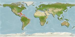
Native range
|
All suitable habitat
|
Point map
|
Year 2050
This map was computer-generated and has not yet been reviewed.
Conger esculentus
AquaMaps
Data sources:
GBIF
OBIS
Envoyez vos
Photos
et
vidéos
Pictures
|
Images Google
Conger esculentus
Picture by
Projeto Tamar
Curaçao Island country information
Common names:
[No common name]
Occurrence:
native
Salinity:
marine
Abundance:
|
Ref:
Importance:
|
Ref:
Aquaculture:
|
Ref:
Regulations:
|
Ref:
Uses:
no uses
Comments:
Probably occurring in the area. Verification needed.
National Checklist:
Country Information:
https://www.cia.gov/library/publications/resources/the-world-factbook/geos/cc.html
National Fisheries Authority:
Occurrences:
Occurrences
Point map
Main Ref:
Cervigón, F., R. Cipriani, W. Fischer, L. Garibaldi, M. Hendrickx, A.J. Lemus, R. Márquez, J.M. Poutiers, G. Robaina and B. Rodriguez, 1992
National Database:
Common names from other countries
Congrio común
,
佳味康吉鳗
,
Úhořovec jedlý
,
... more
Classification / Names
Noms communs
|
Synonymes
| Catalog of Fishes(
Genre
,
Espèce
) |
ITIS
|
CoL
|
WoRMS
|
Cloffa
>
Anguilliformes
(Eels and morays) >
Congridae
(Conger and garden eels) > Congrinae
Etymology:
Conger:
Latin, conger = conger (Ref.
45335
)
.
More on author:
Poey
.
Environment: milieu / climate zone / depth range / distribution range
Écologie
Can't connect to MySQL database (fbapp). Errorcode: Too many connections

")