You can
sponsor
this page
Common name (e.g. trout)
contains
begins with
begins with
ends with
is
Genus + Species (e.g. Gadus morhua)
À propos de cette page
More Info
Plus d'info
Mais info
Langues
Arabic
Bahasa/Malay
Bangla
Chinese(Si)
Chinese(Tr)
Deutsch
English
Español
Farsi
Français
Greek
Hindi
Italiano
Japanese
Lao
Nederlands
Português(Br)
Português(Pt)
Russian
Swedish
Thai
Vietnamese
User feedbacks
Comments &
Corrections
Fish Forum
Livre d'or
Facebook
Citation
Uploads
Lier un site web
Envoyer une photo
Envoyer une video
Upload
references
Fish Watcher
Espèces associées
Espèces pour
Parapercis
Espèces pour
Pinguipedidae
- Classification -
Pinguipedidae
Perciformes/Uranoscopoidei
Teleostei
Chordata
Animalia
Parapercis
snyderi
Jordan
&
Starks
, 1905
U-mark sandperch
Ajouter votre observation dans
Fish Watcher
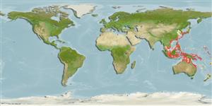
Native range
|
All suitable habitat
|
Point map
|
Year 2050
This map was computer-generated and has not yet been reviewed.
Parapercis snyderi
AquaMaps
Data sources:
GBIF
OBIS
Envoyez vos
Photos
et
vidéos
Pictures
|
Videos |
Images Google
Parapercis snyderi
Picture by
Adams, M.J.
Japan country information
Common names:
Kôrai-toragisu
Occurrence:
native
Salinity:
marine
Abundance:
|
Ref:
Importance:
|
Ref:
Aquaculture:
|
Ref:
Regulations:
|
Ref:
Uses:
no uses
Comments:
Recorded from the Ishima Island, Tokushima Prefecture (Ref. 38029) and Shirahama, southern Japan (Ref. 37690). Specimens are more strongly colored, red with black U-shaped bars. Range of true
P. snyderi
is subtropical Japan (Ref. 48636). Also Ref. 559, 2334, 42740, 48636, 90102.
National Checklist:
Country Information:
https://www.cia.gov/library/publications/resources/the-world-factbook/geos/ja.html
National Fisheries Authority:
http://www.maff.go.jp/eindex.html
Occurrences:
Occurrences
Point map
Main Ref:
Shinohara, G., Y. Sato and K. Matsuura, 2000
National Database:
Common names from other countries
Snyder's grubfish
,
Grub fish
,
史氏拟鲈
,
... more
Classification / Names
Noms communs
|
Synonymes
| Catalog of Fishes(
Genre
,
Espèce
) |
ITIS
|
CoL
|
WoRMS
|
Cloffa
>
Perciformes/Uranoscopoidei
(Sand dwellers) >
Pinguipedidae
(Sandperches)
Etymology:
Parapercis:
Greek, para = the side of + Greek, perke = perch (Ref.
45335
)
.
More on authors:
Jordan
&
Starks
.
Environment: milieu / climate zone / depth range / distribution range
Écologie
Can't connect to MySQL database (fbapp). Errorcode: Too many connections

")