You can
sponsor
this page
Common name (e.g. trout)
contains
begins with
begins with
ends with
is
Genus + Species (e.g. Gadus morhua)
About this page
More Info
Plus d'info
Mais info
Languages
Arabic
Bahasa/Malay
Bangla
Chinese(Si)
Chinese(Tr)
Deutsch
English
Español
Farsi
Français
Greek
Hindi
Italiano
Japanese
Lao
Nederlands
Português(Br)
Português(Pt)
Russian
Swedish
Thai
Vietnamese
User feedbacks
Comments &
Corrections
เวทีแลกเปลี่ยนความคิดเห็นเกี่ยวกับปลา
สมุดเยี่ยม
Facebook
การอ้างอิง
Uploads
Attach website
Upload photo
Upload video
Upload
references
Fish Watcher
Related species
Species in
Micromesistius
Species in
Gadidae
- Classification -
Gadidae
Gadiformes
Teleostei
Chordata
Animalia
Micromesistius
poutassou
(Risso
, 1827)
Blue whiting
Add your observation in
Fish Watcher
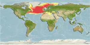
Native range
|
All suitable habitat
|
Point map
|
Year 2050
This map was computer-generated and has not yet been reviewed.
Micromesistius poutassou
AquaMaps
Data sources:
GBIF
OBIS
Upload your
photos
and
videos
Pictures
|
Google image
Micromesistius poutassou
Picture by
Svensen, R.
Greenland country information
Common names:
[No common name]
Occurrence:
native
Salinity:
marine
Abundance:
|
Ref:
Importance:
|
Ref:
Aquaculture:
|
Ref:
Regulations:
|
Ref:
Uses:
no uses
Comments:
Occurs in the waters around South -and Southeast Greenland. Common at Dohrn Bank. Also Ref. 9925, 40.
National Checklist:
Country Information:
https://www.cia.gov/library/publications/resources/the-world-factbook/geos/gl.html
National Fisheries Authority:
Occurrences:
Occurrences
Point map
Main Ref:
Muus, B., F. Salomonsen and C. Vibe, 1990
National Database:
Common names from other countries
Merlan bleu
,
Bacaladilla
,
غُبَر أزرق
,
... more
Classification / Names
ชื่อสามัญ
|
ชื่อพ้อง
| Catalog of Fishes(
สกุล
,
ชนิด
) |
ITIS
|
CoL
|
WoRMS
|
Cloffa
>
Gadiformes
(Cods) >
Gadidae
(Cods and haddocks)
Etymology:
Micromesistius:
Greek, mikros = small + greek, mesos = middle + Greek, istion = sail (Ref.
45335
)
.
More on author:
Risso
.
Environment: milieu / climate zone / depth range / distribution range
นิเวศวิทยา
Can't connect to MySQL database (fbapp). Errorcode: Too many connections

")