| Ecosystem |
Humboldt Current |
| Type |
Sea/Bay/Gulf |
| Salinity |
saltwater |
| Other Names |
|
| Location |
|
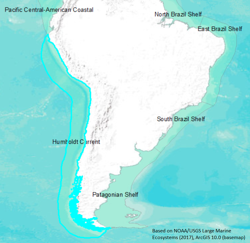
LME SAU No 13. From northern Peru to around Fireland. LME2002, LME2006, SAU 2008. |
4° S 54° S - 90° W 71° W |
|
| Location Map |
Humboldt_Current.png |
| Size Ref |
|
River Length |
|
Area |
2557713 km2 |
Drainage Area |
|
|
| Depth |
|
Average Depth |
|
Max Depth |
|
Ref |
|
|
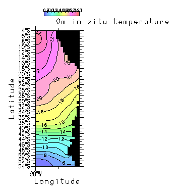
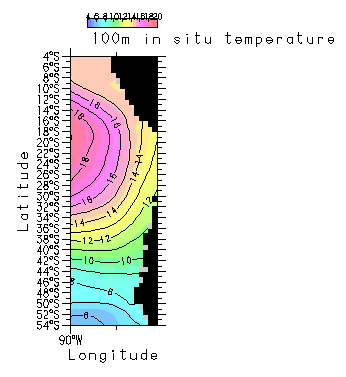
| Temperature |
|
| Description |
The Humboldt current ecosystem is one of the major upwelling systems of the world. As with other eastern boundary currents, the Humboldt current system is predominantly an equatorward flow of cold, low salinity water with complex flows and counter-flows out to 1,000 km from the Peru-Chile coast. The Chile-Peru Oceanic current is a sluggish (0.04 m/s), wide flow toward the equator that coincides with the boundary of the anticyclonic gyre of the Southeast Pacific. (Robles et al., 1990) Shoreward of the Chile-Peru Oceanic current, the Peruvian Oceanic Countercurrent flows southward at approximately 0.06 m/s. (Wyrtki, 1967) The faster Humboldt Current is closer to the coast, approximately 300-400 km offshore, with velocities at 200 m depth greater than 0.18 m/s. Another southern counterflow occurs at 100 m depth off Peru and 200 m depth off Chile. The Gunther Current is another southern flow occurring at 100 m depth off Peru and 200 m depth off Chile. It is low in oxygen (less than 1 ml/l) and nutrient rich. (Brockman et al., 1980; Robles et al., 1990; Alheit and Bernal, 1993) (http://www.na.nmfs.gov/lme/text/lme13.htm). |
| Comments on faunal list |
Area from SAU (November 2015). |
| URL 1 |
http://www.seaaroundus.org/lme/13.aspx |
| URL 2 |
|
| Ecosystem Checklist Link |
|
| Total |
|
Species |
Families |
Species |
Families |
Reference |
|
731 |
199 |
|
|
|
|